Explore the Brent River Park
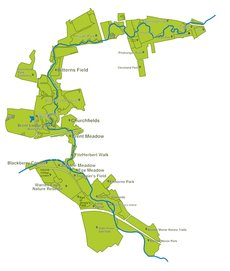
Our Brent River Park is a strip of open green spaces following a 7km curve of the River Brent as the river meanders west and then south through Perivale, Greenford, and Hanwell in the London Borough of Ealing.
Northeast of the Park boundary at the Ruislip branch of the Central Line the river flows through the London Borough of Brent from Brent Reservoir at the Welsh Harp. Brent Reservoir is fed by two streams, the Silk Stream and Dollis Brook. The River Brent is mainly canalized from its junction with the Grand Union Canal below Hanwell Flight, near Green Lane, Hanwell and beyond the southern boundary of the Park at the M4 at Osterley, the combined waterway flows through the London Borough of Hounslow to enter the River Thames at Brentford. The River Brent is the main surface water drainage artery for a large area of northwest and west London.
Brent River Park covers over 400 ha of open space and contains designated Sites of Importance for Nature Conservation (SINC), formal parks, golf courses, sports grounds and allotment sites. Part of the Brentham Garden Estate and most of the Churchfields and the St Mark’s Church and Canal Conservation Areas lie within our park boundaries.
About 80% of our park is owned by London Borough of Ealing, some of which is leased to and managed by private clubs and tenants. About 15% is owned by other public bodies, including Network Rail and the Canal & River Trust, and about 5% is owned privately. Our entire park, (with the exception of a Major Employment Location at Trumpers Way), is classified as Metropolitan Open Land.
Our Brent River Park is crossed by several major roads; the A40 Western Avenue, the B455 Ruislip Road, the A4020 Uxbridge Road and the M4 Motorway in an east-west direction, and the A4127 Greenford Road, B454 Windmill Lane and B452 Argyle Road in a north-south direction.
The Great Western Main Line crosses our park in Hanwell over the famous Wharncliffe Viaduct, and the Greenford Loop Line crosses at Perivale. A single track freight line runs from Southall to Brentford crossing our park between Hanwell and Osterley. Two London Underground lines fall just outside our park: Piccadilly at Boston Manor and Central at Perivale and Hanger Lane. The Elizabeth Line runs through the park from central London out to Heathrow. The main arm of the Grand Union Canal is a major feature of our park and includes 7 locks giving an elevation change of 21m.
Large areas of our park are open to free public access and there are about 50 roadside entrances for pedestrians. There are many footpaths (some statutory, some permissive) and cycle paths. The Brent River Park is accessible and open to everyone and we are committed to ensuring this will always be the case.
With increasing public awareness of the landscape and wildlife value of our remaining open spaces and of their importance for education, well-being and informal recreation, the attention we give to our green and blue spaces is more crucial than ever. We each have a vital role to play in protecting our Brent River Park for the benefit of both wildlife and people, now and in the future.